18 Attractions to Explore Near Plage de l'Ostriconi
Top Activities Near Plage de l'Ostriconi
Filter By Date
//
Sort By
Attractions & Activities Near You
Checkout attractions and activities near your current locationAll attractions near Plage de l'Ostriconi
Désert des AgriatesThe desert of Agriates or the Agriates is a territory of Corsica shared between the micro-regions of Balagne 1 to the west and Nebbio. The only inhabited place of Les Agriates is the scattered hamlet of Casta . Some tourist guides present it as the only desert in Western Europe. This wild and untamed little desert sums up the beauty of Corsica. There are among the most beautiful beaches on the island, incredible scenery, and a preserved scrubland.
Plage de SalecciaThe beach of Saleccia is located in Corsica , in the Agriates Desert , territory of which the origin of the name refers to "fertile agricultural land" 1 . The beach is considered one of the most beautiful on the island. The beach of Saleccia is a long strip of fine white sand that stretches for 1,200 m.
Plage du LotuThe Beach Loto Note is a beach north of the coast of Agriates Desert in Corsica, located between Punta di Ravijola and Punta Cavallata, bathed by the Mediterranean Sea. The beach is shared for half between the municipalities of Santo-Pietro-di-Tenda to the west and Saint-Florent to the east. Loto beach is accessible by sea and, on foot from Saint-Florent, by the customs trail which runs along the entire coast of the Agriates desert.
Col de TeghimeThe Col de Teghime is one of the main passes in Corsica. It offers a view of the two coasts of Corsica, with Bastia and the Tyrrhenian Sea to the east, Saint-Florent, the Desert of Agriates and the Mediterranean Sea to the west. A monument at the pass pays homage to the sacrifice of Moroccan goumiers in this battle and in the Liberation of Corsica. One of the nice location which was flourished with stunning views and natural beauty.
Calvi BeachCalvi is a city on the French island of Corsica and the biggest tourist center of the island proper. One of the nice sandy beaches in this area which is calm and quiet and also there is so many opportunities for adventure activities also. Calvi has a rich and chequered history. The earliest found remains of settlers in Calvi date back to the Neolithic period, in one of its many caves.
Gulf of RevellataThe Gulf of Revellata is a gulf of the Mediterranean which is located in the town of Calvi in Haute Corse. It is a privileged scooping site for water bombers. It is also an underwater sanctuary which is one of the most famous diving spots in Corsica. It is a conserved area that is blessed with natural beauty.
Revellata lighthouseThe Revellata lighthouse also called the Gulf of Calvi lighthouse, marks the northwest coast of Corsica, from the Gulf of Galéria to the coasts of Agriates. The current lighthouse is a square tower, centered on a rectangular base. It is in masonry stone, with smooth plaster and exposed stone angles. an architectural wonder which was located at the tip of a cliff. it offers a panoramic view of this area and also a nice location to hangout.
Monte CintoMonte Cinto is the highest mountain on Corsica with a height of 2706m. It is the main peak that separates the Golo valley in the south from the Asco valley in the north. One of the main trekking and rock climbing locations in this area and offers a panoramic view of the whole area from the top of the mountain.
Étang de BigugliaThe Étang de Biguglia is a Corsican lagoon located south of Bastia, on the Bevinco river. It is the largest coastal pond on the island which covers 1,450 ha. The fort of Biguglia located north of the pond bears witness to the strong activities of the past. This pond has been exploited for many species of fish. A nine picnic spot and also you can have fish from this pond and also swimming is allowed here.
Monte San PetroneThe Monte San Petrone is a mountain located in the department of Haute-Corse. The slopes of this schist massif are covered with chestnut trees returned to the state of the forest, which earned it the name of Castagniccia. One of the nice trekking destination and also a place which is blessed with natural beauty.
Paglia OrbaMount Paglia Orba is one of the most famous mountains in Corsica. it is an isolated massif, and dominates the west coast of the island; it is nicknamed the " Corsican Matterhorn " or even the "Queen of Corsican mountains". It is also one of the nice trekking destinations in this area too.
Regional Natural Park of CorsicaThe Corsica Regional Nature Park extends over 350,510 hectares, which represents about 40 % of the island. This park is a paradise for those who love nature and beautiful landscapes. It is also one of the challenging trekking destinations and also you can perform so many adventure activities here. It is also home to a large variety of flora and fauna.
Gorges du TavignanoThe Tavignano is a French coastal river on the island of Corsica, which flows into the Tyrrhenian Sea. One of the nice location which is away from city life and is blessed with natural beauty. A nice trekking destination and also a good camping site.
Vallée du FangoThe Fango Valley was designated a biosphere reserve by UNESCO on1 st March 1977. Its heart is the Piriu Forest, made up of maritime and black pines as well as remarkable centuries-old holm oaks which are said to be among the oldest in the world. The Piriu yeuseraie has not been exploited since 1850. One of the nice trekking destination and also there is a beautiful river flowing through this area.
Moulin MatteiIt was one of the rare windmills that Corsica knew. But especially it is necessary to know that Mattei's name is more often associated with the mark of aperitif. From this mill, one can admire a remarkable sight on the sea as well as on the Centauri's picturesque port with a height of 365 meters and it is open to tourists. It was built at the end of the 18th century and had so many renovations later.
Col de VergioThe Vergio pass (in Corsican Bocca Verghju ) is a collar of Corsica between Corte and Vico . It thus connects Albertacce in Niolo ( En-Deçà-des-Monts ) to Évisa in Deux-Sevi ( Au-Delà-des-Monts ). It is the highest road pass on the island. It is, with the passes of Vizzavona , Verde and Bavella , one of the four “great passes” of Corsica, making it possible to connect the two sides of the island from the interior.
Gorges de la RestonicaLa Restonica is a river that originates from Lake Melo at an altitude of 1,711 meters on Monte Rotondo. Its course is 18 km before joining the Tavignano in Corte. the Restonica gorges offer multiple possibilities for swimming and hiking. A winding road allows you to reach the sheepfolds of Grotelle which are the starting point for the lakes of Melo and Capitello. Its course is dotted with waterfalls and natural pools of clear and freshwater, in its first part, then becomes less uneven in the res
Lac de NinoMost beautiful and the second largest lake located at the altitude of 1743 m and it occupies 6.3 ha within the Camputile Plateau. The lake also serves as a source of Tavignano, Corsica’s second-largest river flowing east into the Tyrrhenian Sea. It is also a hiking attraction in this area. One of the nice location which was not at all damaged by the public and it offers a nice view of nature.
Map of attractions near Plage de l'Ostriconi
Top hotels near Plage de l'Ostriconi
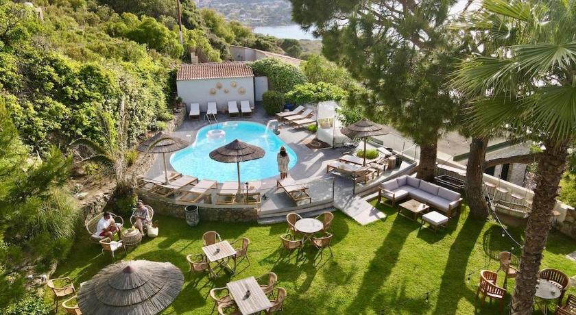
24 Reviews
8.8
$231.91 per nightSelect
Know more about Plage de l'Ostriconi
Plage de l'OstriconiThe Ostriconi is a small French coastal river that flows in the north of the department of Haute-Corse in the Corsica region and which empties into the Mediterranean Sea. One of the nice place to spend some leisure time and It flows from the southeast to the northwest, creating a valley called Paesi d'Ostriconi, located between the micro-regions of Nebbio and Giussani .